Oscar up the Gog

                    www. Jawapro .com
                    A Seriously Froody Website


Image
Boundary Islet

Author: jawapro
Date: Sat 27/09/2008 04:39 PM


 Image
 
Simple question for you. Which Australian state does not share any land borders with any other state?
 
Tasmania!
 
Well - you're wrong.
 
No state meets that description.
 
But hang about - Tassie is an island - of course it has no land borders.
 
That's the commonly held belief - but it's wrong. Officially, we do have a land border with Victoria.
 
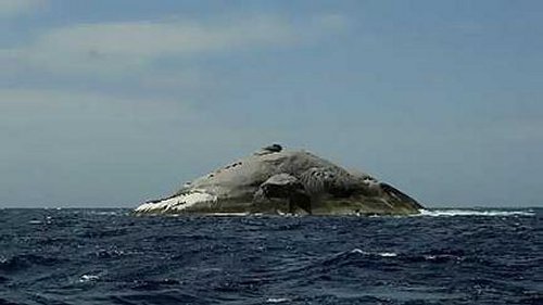
Out in the middle of Bass Strait are some islands. One of them is called Boundary Islet.
 
As you can see from the photo - it's not much of an island. Wouldn't rank high on many people's must-see lists.
 
It's only six hectares, which is smaller than my parent's hobby farm - but it's somewhere I'd love to go someday. (Correction - it is slightly larger than my parents hobby farm. My parents farm is 9 acres approx, and this is 14 acres approx - I got my measurements mixed up).
 
Why is it such a cool destination?
 
Well, due to a mistake years ago drawing out the borders between Tassie and Vic (NSW at the time, before Vic branched off) both Tassie and Vic own part of this island.
 
This is the only place where you cross the border from Tas to Vic on foot (not counting walking around on ships).
 
Anyway - just thought it was cool enough to be worth sharing.
 
Thanks to the Einstein Factor for spilling the beans.
More info can be found at these links:
 
http://www.theage.com.au/news/National/States-divided-between-Diemen-and-deep-blue-sea/2005/01/19/1106110810527.html
http://en.wikipedia.org/wiki/Boundary_Islet
http://everything2.com/e2node/Tasmania%2527s%2520land%2520border%2520with%2520Victoria


Comments: 4
 

Image

Comment: 1

Author: DarthOblivion
Date: Sun 28/09/2008 08:25 AM


Now that is a random fact.


Image

Comment: 2

Author: LittleSis
Date: Mon 29/09/2008 09:30 AM


I bet its hard to get to- and its probably covered in bird poo.

But as a marine scientist I could come with you and check out all the seabirds that would use the island.


Image

Comment: 3

Author: Nifen
Date: Tue 30/09/2008 12:47 PM


google maps show it. and it says this on it.

"Boundary Islet is an islet about 60,000 square metres in size in the Hogan Group of islands and islets at latitude 39°12' S, south of the Wilson's Promontory, the southernmost part of both mainland Australia and mainland Victoria. The boundary between Victoria and Tasmania is a parallel similarly at latitude 39°12'; on it is thus Tasmania's only land boundary, and at 85 metres long it is the shortest land border between any Australian states. The position of the island was surveyed in 1801 by Captain James Black, who erred in placing the islet further north than it is. It was later found that the border at 39°12' S actually passed through the islet. Boundary Islet was once known as North East Islet."


I must admit, that picture doesn't really show the island well. From above it looks bigger.


Image

Comment: 4

Author: jawapro
Date: Tue 30/09/2008 01:38 PM


Kool - I'll have to give it a look.

And I just noticed that the size of the island is measured in hectares, not acres, so I was wrong with the size being smaller than my parents farm. It's actually slightly larger. Not much though.

Still - how many people can say they've STOOD on the border between Tassie and Vic? It would still be a great place to visit (for about 10 minutes).